I searched all over and found information on custom map making that is years old, or inaccurate. I have followed posts and links in those posts. Leaving my question unanswered.
How do you make a custom map from start to finish?
Making the map in a bitmap picture, setting the properties, bit rate, correct pixels per inch, the correct colors so it will render correctly, and which map render software is the best to use.
To make a map file with a bitmap, you have to either make your own mapping software, or use an already existing one.
So far, from what i gather of your post, you might want to take a look at Dragon.
As for map rendering, i don't know.
I made my own mapping software and i'm still coding it little by little, so if you make your own, be ready to lose quite some time on it (that is if you start completly from scratch like i did).
On a side note, it might be easier to offer assistance if you tell us what you tried, what you intend to do to do your mapping, etc.
If i pump out any tutorials, chances are that you may have already deemed them as outdated.
Tried using GIMP to set up, color, deserialize, and set all other properties that some tutorials told me to do.
Used Dragon_10362_Imod9+, Dragon_10362_Imod13, dragonmod9, and dragonmod9 with little and no success. If it did render the map and static files, I got the dragon picture that I uploaded.
Next tried using UOLandscaper with the color palette that they suggested. The only thing that came out like the color suggested was grass. Dirt came out as mountains, snow was water, the swamp was sand, and mountains was dirt.
We would like to make a couple of custom maps for players to play on that have not been used yet. My co-owner can deco great, but I am the one who handles the meat-n-potatoes of the behind-the-scenes stuff. She has made a custom map that we want to use, the issue we have is getting it to render correctly.
But today we went thru all the colors, found out which ones will render as what and got rid of the ones that wouldn't render. So now we know what colors will turn out as what and what goes.
Although, any more advice u all can give would be great.
Small instruction to draw maps and dungeons for calculation by AwA or the program Dragon.
The following is required: A bitmap graphics program that can process large graphics (Adobe Photoshop is the most suitable).
Basics:
The UO card consists of 6144 x 4096 tiles, so the graphics to be calculated must have this number of pixels.
The graphics must be saved as uncompressed as a Windows BMP with 8 bits or 256 colors.
The program only calculates the basic styles with their different height values and the individual transitions between the individual species, and it sets the coastal strips and various outer walls for the dungeons.
The following transitions are automatically calculated between 2 types:
grass / pavement
grass / unpaved paths
grass / forest
grass / jungle
grass / mountains
Grass / desert
grass / snow
grass / coast (choice between light or dark coastline)
forest / unpaved paths
forest / jungle
forest / mountains
forest / desert
forest / coast
jungle / unpaved paths
jungle / coast
desert / unpaved paths
desert / jungle
desert / Mountains
desert /
desert
paths desert / coast snow / dirt roads
snow / mountains
snow / coast
dirt roads / mountains
dirt roads / coast
Dungeoncavefloor is rounded off
Dungeon Floorplates sandstone-colored / Lava
The following items are calculated to be integrated by means of a Staic-makers for Sphere or UOX:
All coastal parts (waves) of water
Dungeon Walls for Dungeon Floor Pates brown
trees and forests
with sandstone walls at Dungeon Floorplates sandstone-colored
marble walls with marble Floorplates
(where each the possibility that the front walls are only half-height or have full height)
Further calculations have not been elaborated at the moment or are not possible, furthermore there is no calculation at places where more than 2 tile types meet, since this would result in a considerably greater computing effort and there are no intermediate tiles anyway ,
To ensure that the transitions are
calculated correctly, there are a few points to keep in mind when drawing. Side-by-side only of landscape types where there is also a between calculation, there will be no hard transitions that need
to be revised. At least one pixel field of 2x2 pixels must be available for transitions otherwise the transitions cannot be calculated correctly.
Within a type of landscape, the number of pixels does not matter between the different heights, just make sure that they can also be walked on by games (i.e. no other grass height zero to the next tile grass height 45).
Ascents in mountains should be as gentle as possible, otherwise an the player behind it is covered up to 10 fields by the mountains.
All dungeons must be surrounded by a border with a minimum of 2 pixels black unwalkable since otherwise the walls will not be properly calculated.
Between 2 different water levels there must always be 2 tiles of a different type of soil in order to create a waterfall.
Preparations for drawing a map (based on Adobe Photoshop )
Create a new graphic with 6144 x 4096 pixels.
Switch the mode of the graphic to 8-bit mode.
Load the color table.
To insert a Photoshop color palette please click on Swatches at the color window and then on the arrow to the right. Now you can replace the color palette with the enclosed color table (Replace).
Before you start drawing you should have a rough idea of how big the land mass should be or how it should look.
The landmass and islands should be stored in a sea, which in turn should be surrounded by a mountain range, so that players who are traveling with a ship do not eventually reach a black edge.
To what extent the country is then available in one piece or as islands everyone must know for themselves.
You should start with a rough representation of the map, which you then work out in more and more detail.
In order to achieve a certain atmosphere for InGame, one should not make the level of the surface and the height too large.
You should also see whether certain types of soil should be right next to each other.
In order to represent crossings with 2 levels in dungeons, you have to put the lower level paint and the other one later by hand using floor plates and then let them make static.
I would probably add an idea to this. You know, over the years I do graphics and create UO files, I've met many people and taught them how to work for this game. But there was always a problem. People want to create, but they don't want to admit they don't know anything. Working with different programs for Ultima Online is often easier than working with Adobe photoshop (Gimp, paint net etc). To work on graphics, we need to control a civilian program. I knew people who edited images in the "paint" windows program. It is a catastrophe.
Friends who always encounter this problem, master Dragon Mod or UO Landscaper, or manage to create a gump or art image. But you can't create the right bmp format. Don't despair and learn. But not here on the forum. About Adobe Photoshop (Gimp etc), learn at source. There are plenty of instructions on the world's website. Here you will get information on how to set it up, as in this case of this topic. But to find and learn the job, to test trial and error, nobody will do it for you. So let's go to work boys and girls.
The map sizes for Trammel and Felucca are actually larger (depends if you use Pre-ML or post-ML clients) and I have been making UO custom maps for a long while with Dragon, MapCreator, and with UOLandscaper; MapCreator is my own rendition of UOLandscaper so it really doesn’t matter which you use because they work the same - they are clones of one another except UOLandscaper is coded in VB whereas MapCreator is written in C# and is open source; so the community can edit it.
As for the Custom Map thing, the best editor to use is a combo of both UOLandscaper and CentrED. UOLandscaper is the only editor available that is capable of 3way transitions. MapCreator uses the same engine, but the 3way transition editor has not been included. The reason is because I coded MapCreator when I was starting out and I was unable to get the 3way transition editor to work properly when I tried to recode it in C#.
As with everything this process is a matter of preference and therefore you will get several different reasons to go with one editor moreso than another. My recommendation is to try and use all of them to get a feel. I would also opt to go with Adobe Photoshop rather than GIMP or another free paint program, only because it’s much more straightforward to us in my opinion. Also UOLandscaper and MapCreator were designed to work with Adobe Photoshops color table and swatches
If all else fails you can always solicit Eri to make a map for you. Her map editor Mass is also a great one to use, though I still have yet to master it. Lol
I was able to receive some custom map files from a friend who hasn't ran a shard in years. He said I could add them to mine. I want to edit them with CentrED+ and I don't know the map size. How would I find out. BTW--the friend forgot what size they were, its been that long.
Good evening everyone, I know the last post here was almost two years ago but I need your help, I started to create my map with dragonmod and I managed to create the entire grass area but the passage from grass to water is getting with error and you get a brown spot, does anyone know how to solve it?
Good evening everyone, I know the last post here was almost two years ago but I need your help, I started to create my map with dragonmod and I managed to create the entire grass area but the passage from grass to water is getting with error and you get a brown spot, does anyone know how to solve it?
Which dragonmod are you using? There are a few different ones out there (mod9, etc.) Most people use Mod9/Mod9+. I think Mod11 has some issues with coastlines and/or was never fully completed.
There should be a designated color for "shallow water". You need to surround shorelines with at least 5-6 pixels of "shallow water". Dragon will then place the correct static tiles on the shorelines. (Looking at one of my old dragon maps, it looks like for ocean (deep water) you use water at Z -5, and for shallow water (which goes around the coastlines) you use water at Z 5. For Dragon mod 9, the deep water is RGB 0 0 102 and shallow water is RGB 0 0 153.
Also, as others have mentioned, you need to make sure your map image BMP is using the same palette as the Dragon color table, as it's really the index number in the image palette (not the color used by that index number) that Dragon is using to identify and render the terrain transitions. So if you have a map image that isn't using the color table's palette, it probably isn't going to convert to MUL correctly. (This could be why some of your earlier attempts were producing odd results).
I think most of the dragon mod packages include a palette file in the "Addons" directory (which I think is for Adobe Photoshop and possibly also one for Paintshop Pro). But you can also create one yourself using the color table BMP as the source for the palette. Exactly how to do this depends on the paint program you are using, but most paint programs can load and save a palette index from an image). There also might be an option in Dragon itself to generate the palette files (it's been a long time so I forget).
It actually has nothing to do with transparent water. Unlike other transitions, coastlines are transitioned using static images vs. terrain. So all coastlines in UO will look like this (with those brown spots) if the correct static items to transition the terrain to the water are missing.
In your map image you have to use shallow water around the coastlines (as described above), and then Dragon will place the proper statics to transition the coasts to the ocean properly. (Remember that you have to generate both map and statics, as the coastline transitions are static items, not terrain).
ok I understand, but in the dragon program there is an executable that I use to transform the BMP file into map0.mul, I use that same executable but I change the name that I'll save the file to statics0.mul or is it another executable?
I can't answer this question, I don't work with DragonMod. But it's an intuitive program, I'm sure you'll figure it out yourself. Furthermore, I would just like to confirm what my colleagues have written here. That's just the way it is. This is not a mistake, on the contrary it is the correct behavior when generating maps. I'll just add information to that. Working on a map, painting it in Adobe Photoshop is very challenging. You have to watch how to paint pixel by pixel at the bends of rivers, coasts, other terrain and so on. If you bend a landscape fractal, don't do it sharply. Sharp corners will always generate what you describe. Whether you're doing it with a dragon or a landscaper. It will always be the same. Bend the terrain fractal smoothly. You can then finish the transparent water in the center +. Although, I personally do it right in the UO landscaper, but I also adapted it for it and mainly modified the files and work methodology. This is too individual. Therefore, I would rather recommend that you generate a map first and then create transparent water in centred + (of course, if you want to create it at all).
ok I understand, but in the dragon program there is an executable that I use to transform the BMP file into map0.mul, I use that same executable but I change the name that I'll save the file to statics0.mul or is it another executable?
Run Dragon.exe first to generate the map file. Then run DragonSP to generate the statics. Make sure both Waterx2.scp and 2xWater.scp are selected in DragonSP to include the coastlines.
Dragon tutorial here (see #10 for generating statics):
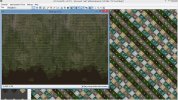
Good guys once again, I managed to go through all the previous steps and I'm already able to create a correct map with all the edges of land and water ok but now a problem has arisen that I think will not be possible to solve and will probably throw all the work in the trash. Let's see if I can explain the problem and if someone will be able to answer me, I created the map and used the entire available zone, that is, I also took advantage of the black part of the map, the part that contains the dungeons and the green zone. The problem now arises is in specific areas of the map there is an error that I think is because I used the black areas of the map where it is either with a black band on the map or sea appears instead of land, I leave images below, some suggestion?
(as you can see in the images the black zone is actually like it doesn't exist because the part where the map ends in one image sticks exactly with the part of the other image)
This behavior has to do with map "wrap points" and is hardcoded into the client. To change this, you'll need to either hex edit the official client, or use a custom client like Classic UO and make edits to the source code. You'd also need to make edits to the code for ships in the server.
If you don't need the entire map to be one large map, you can just move your edits in the dungeon area away from the area where the map wraps.
in client it is hardcoded where the black dungeonarea starts. so you can NOT create over the whole size your map, cause there is that break like you have in your second picture
the first picture is ok. you need to know, that uo shows black if you are at the border of the map - that is normal.
This behavior has to do with map "wrap points" and is hardcoded into the client. To change this, you'll need to either hex edit the official client, or use a custom client like Classic UO and make edits to the source code. You'd also need to make edits to the code for ships in the server.
If you don't need the entire map to be one large map, you can just move your edits in the dungeon area away from the area where the map wraps.
hello once again, thank you in advance for your help because with that i have learned a lot. well after reading your answer i came to the conclusion that i will not be able to use the whole map because i make changes directly in the client i think it goes far beyond my capabilities and therefore i will give up this "project" and think of a new one. anyway I'll leave a picture of what I was doing just to give you an idea.
(for me it only made sense to make this map occupying everything because it would have good areas, if it decreases i think it will be very small and weird)
in client it is hardcoded where the black dungeonarea starts. so you can NOT create over the whole size your map, cause there is that break like you have in your second picture
the first picture is ok. you need to know, that uo shows black if you are at the border of the map - that is normal.


")